- Research
- Open access
- Published:
Connecting community’s perspectives on tsunami risk to anticipated future tsunamis: a reflection from a progress of tsunami preparedness from a coastal community in Aceh-Indonesia after 19 years of the 2004 Indian Ocean Tsunami
Geoenvironmental Disasters volume 10, Article number: 21 (2023)
Abstract
This paper reflects on the progress of tsunami preparedness in a coastal community in Aceh, Indonesia, nearly two decades after the catastrophic 2004 Indian Ocean Tsunami. The research employs a comprehensive approach to thoroughly evaluate and comprehend the community’s preparedness, its correlation with local perceptions of tsunami risk, and delves into the prevalence of tsunamis in the area, with a specific emphasis on the significant impact of the 2004 Indian Ocean Tsunami on the coastal community of Aceh. To investigate the community’s readiness and the potential impacts of tsunamis at the study site, tsunami simulations were performed using the shallow water equation within the COMCOT (Cornell Multi-grid Coupled Tsunami) model. These simulations assessed run-up and inundation scenarios, thereby providing justification for the potential tsunami impact in the area. Modelling the scenario of tsunami in the region is important to measure the potential impact and estimation time for community to prepare the evacuation plan. In addition to the numerical modeling, a mixed-method approach was employed, involving the distribution of questionnaires and conducting in-depth interviews with 150 respondents directly on-site. These assessments yielded valuable insights into community perspectives on tsunami risk and their preparedness measures. The findings contribute to the development of effective strategies for disaster management by integrating local knowledge, experiences, and socialization programs. The study emphasizes the significance of ongoing endeavors to enhance community preparedness and mitigate the consequences of tsunamis.
Introduction
Seismic activity in the waters off western Sumatra occurs quite intensively. This can be attributed to its complex tectonic setting resulting from the convergence of the Indian Plate with the Eurasian/Indian and Australian Plates (McCaffrey 2009). The Sumatra fault, spanning 1900 km with multiple segments, is formed due to the interaction between these plates (Sieh and Natawidjaja 2000). This dynamic interaction generates tectonic earthquakes, some of which trigger tsunamis (Haridhi et al. 2018; Lange et al. 2018; Weller et al. 2012).
Over the past two decades, Sumatra has been a focal point of tsunami occurrences in Indonesia, with 60% of all tsunamis impacting the region and inflicting significant land damage. This era of increased tsunamigenic events commenced with the devastating Indian Ocean Tsunami (IOT) on December 26, 2004. The IOT was initiated by an earthquake ranging in magnitude from 9.1 to 9.3 Mw (Ammon et al. 2005; Lambotte et al. 2006; Park et al. 2005; Vallée 2007), the variation in magnitude being attributed to varying assumptions about fault geometry. Chlieh et al. (2007) calculated a magnitude of 9.15 Mw using a coseismic model with a fault dimension of 1500 km in length and 150 km in width. Subsequently, an 8.7 Mw earthquake struck the southeastern side of the IOT source, leading to another destructive tsunami affecting Nias and Simeulue Islands (Hsu et al. 2006; Subarya et al. 2006). This rupture occurred precisely in the location of an 8.5 Mw earthquake in 1861 (Gahalaut and Catherine 2006). In addition to these events, other tsunamis, such as the one in 2005 triggered by a 7.8 Mw earthquake off the Mentawai Islands (Newman et al. 2011), have impacted the region. The waters off West Sumatra Province have also witnessed numerous significant earthquakes (exceeding 8 Mw) in the past, as meticulously analyzed by Philibosian et al. (2017), who studied eight rupture events spanning from 1520 to 2000. Notably, two out of these three major tsunamis directly affected the Aceh mainland in northern Sumatra. Further underscoring the region’s seismic vulnerability, April 11, 2012, marked a historic moment with the occurrence of the largest recorded strike-slip earthquake (8.6 Mw and 8.2 Mw) in history. With only a 2-hour interval between the two events, this unprecedented seismic activity (Delescluse et al. 2012; Duputel et al. 2012; Lay et al. 2005; Wang et al. 2012; Yue et al. 2012). Geodetic and geomorphic studies assessing the distribution of slip/locking on the Sumatra fault, as conducted by Tabei et al. (2017), suggest that the potential for significant earthquakes in Aceh remains considerable.
Notably, the historical record extends far into the past, with tsunamis having left their mark on Aceh’s shores for centuries. Paleo-tsunami studies by Monecke et al. (2008) along the west coast of Aceh (Meulaboh) have unveiled evidence of recurring tsunami damage dating back a millennium. Similarly, investigations by Sieh et al. (2015) along the Lambaro coast have identified two distinct tsunamis occurring between 1394 and 1396 and 1450–1453. Also, Wassmer et al. (2015) applied the anisotropy of magnetic susceptibility (AMS) technique to analyze a historical tsunami deposit, uncovering three distinct uprush pulsations and offering crucial insights into the tsunami’s orientation, energy, and flow patterns. A comparative analysis between the 4220 BP tsunami and the 2004 IOT revealed behavior similarities in the Lampuuk coastal plain, attributed to bay topography influencing uprush flow direction. Even more intriguingly, Rubin et al. (2017) have uncovered ancient tsunamis dating back 7400 years before the IOT through paleo-tsunami studies in a cave on Aceh’s west coast. These studies, complemented by archaeological surveys along a 40 km stretch of the northern coast, which provide evidence of a devastating tsunami around 1391 (Daly et al. 2019), underscore the enduring and cyclical nature of tsunamis in Aceh.
Understanding and reconstructing these past events is pivotal in deciphering tsunami characteristics, often accomplished through advanced simulations (Kim et al. 2013; Koshimura et al. 2009; Martin et al. 2019). This knowledge serves as the foundation for regional assessments of tsunami disaster probability, a crucial component of early warning and preparedness efforts (Horspool et al. 2014; Mulia et al. 2020; Selva et al. 2021), aligning with the principles outlined in the Sendai Framework, which emphasize disaster understanding and preparedness enhancement (United Nations Office for Disaster Risk Reduction 2015).
The magnitude of the 2004 IOT and its far-reaching impacts classify it as a mega-hazard (Synolakis and Bernard 2006). Notably, the coastal population’s experience with tsunamis significantly influences the number of casualties (Imamura et al. 2019). The consequences of tsunamis extend to coastal erosion, which affects livelihoods, including damage to fishponds (Griffin et al. 2013), creating a prolonged cycle of recovery for survivors. Consequently, the post-disaster period has ushered in a new era in Indonesia’s tsunami mitigation efforts, characterized by the development of disaster management regulations and the implementation of technology as tangible components of tsunami mitigation. Nevertheless, despite these strides, enhancing mitigation systems remains a priority, particularly in light of the impacts of the Palu-Donggala Tsunami and the Anak Krakatau Tsunami in late 2018. Indonesia’s status as a developing country, with limitations in acquiring adequate mitigation systems, presents ongoing challenges.
This research is fundamentally rooted in the need to learn from previous tsunami events in Indonesia, which continue to exact a toll on human lives and land infrastructure. Employing a case study approach, this research aims to evaluate the impact of tsunamis based on historical seismic potential. Furthermore, it seeks to map the level of community preparedness in facing potential tsunamis in the study area.

The framework of the idea and research flow
In Fig. 1, a detailed depiction is provided, showcasing the intricate relationship between tsunami simulation and the assessment of community preparedness. This comprehensive research framework encompasses several interconnected components. It begins with an exploration of Tsunami History, delving into historical seismic and tsunami data, including the 2004 Indian Ocean Tsunami, while identifying recurring tsunami events and their impact on Aceh. The framework then extends to the utilization of a Tsunami Model, where potential scenarios, encompassing run-up and inundation, are simulated. Concurrently, the study evaluates Existing Mitigating Systems, assessing their work and effectiveness in mitigating tsunami impacts. The research goes further by delving into the Community Perspective, conducting an in-depth analysis of community viewpoints regarding tsunami risk. This aspect also scrutinizes how local knowledge and experiences shape these perceptions. Simultaneously, the investigation identifies Gaps in Community Preparedness, discerning weaknesses in the community’s preparedness efforts. It considers the multifaceted factors contributing to these gaps, encompassing cultural, social, and economic dimensions. Finally, the framework addresses the Role of Governance, evaluating the involvement of local governance and authorities in disaster management and scrutinizing the policies and initiatives aimed at enhancing community preparedness.
The theoretical implications of this research extend to the development of an integrated model for coastal zone management, encompassing buffer zones to mitigate tsunami damage on land. On a practical level, the research lays the groundwork for coastal settlement planning and the establishment of Temporary Evacuation Sites (TES) and evacuation routes. For policymakers, implementing this study can serve as a reference in formulating or updating Regional Spatial Planning (RTRW), Coastal and Small Island Zoning Plans (RZWP-3-K), and coastal boundary demarcation.
Study location
The research is focused on the coastal area of Teluk Ulee Lheue, Peukan Bada Subdistrict, Aceh Besar Regency, Aceh Province. Administratively, it is located in the Gampong (village) of Lam Guron, Lambaro Neujid, and Lambaro. These three Gampongs are part of the Lam Pageu Mukim, Peukan Bada Subdistrict, Aceh Besar Regency, Aceh Province. The study location is shown in Fig. 2, facing the open sea. Lam Pageu Mukim was selected as the study location based on several considerations. This area is vulnerable to direct tsunami attacks, as evidenced by the impact of the 2004 tsunami and the absence of physical mitigation systems in the field. Additionally, there is available open space to support implementing tsunami mitigation systems. Generally, the local population’s livelihoods are in the agricultural and fishing sectors, as farmers and fishermen (Badan Pusat Statistik 2020). The selection of this location is based on the vulnerability to tsunamis, both historically and the potential assessed through tectonic order assessments in the Indian Ocean. Furthermore, after the 2004 Indian Ocean Tsunami, there has been no physical mitigation implementation except for socialization and evacuation signage efforts (Syamsidik et al. 2019).

Study location

Aerial view of a portion of the study location (Gampong Lambaro Neujid and Lamguron) post-tsunami (left) and after recovery (right)
The area’s topography is relatively flat, with elevations ranging from 2 to 4 m above sea level for the coastal mainland. This coastal area is used for fishing and agricultural purposes, including ponds and rice fields. The settlements are located along the coastal fringe, with several public facilities such as mosques, health centers, and schools. Approximately 500 m from the coast, the topography becomes steeper, characterized by hills surrounding the area. An aerial view of the study area is shown in Fig. 3. The aerial perspective in the photo also reveals the spatial arrangement of the Lam Pageu Mukim post-tsunami and after recovering from the impacts of the 19-year-old Indian Ocean Tsunami.
The 2004 Indian Ocean Tsunami significantly affected Aceh’s coastal areas, including coastline changes, land use, community settlements, and infrastructure (Syamsidik et al. 2019). In addition to the direct impacts on these sectors, there were significant changes in the social aspects of coastal communities following the tsunami. The characteristics of the tsunami that struck the study area were mega hazards, with recorded tsunami heights of 20 m and 13.7 m on the hill slopes of Gampong Lambaro Neujid (Lavigne et al. 2009). The recorded wave heights were influenced by the proximity of the tsunami source to the Aceh coast, categorizing it as a near-field tsunami. Thus, the large-scale waves caused significant damage to the mainland, particularly in the agricultural and fishing sectors. The presence of mangrove greenbelts in the study location did not play a significant role in reducing the impacts of the tsunami. On the contrary, positive effects were observed in the coastal areas of India and Sri Lanka, where the presence of coastal forests was able to reduce the damage caused by a tsunami with heights less than 7 m (Dahdouh-Guebas et al. 2005; Danielsen et al. 2005; Griffin et al. 2013).
The damage to the fishing and agricultural sectors subsequently impacted the livelihoods of the local communities. In the Ulee Lheue Bay coastal area, significant damage occurred to the pond and rice field areas along the coastal mainland. Out of the 149 hectares of damaged pond areas, only 28 hectares (19%) have been successfully recovered ten years since the tsunami (Fahmi et al. 2017). The slow recovery rate in the pond fishery sector is due to substantial damage (erosion) and salinity factors in some ponds (Syamsidik et al., 2015). The recovery process in the agricultural sector, particularly rice fields, contrasts with the situation in the pond fishery sector. Out of the pre-tsunami 189 hectares of rice fields, 80% of these fields have gradually recovered (Fahmi et al. 2017). These data indicate that the agricultural sector has experienced more significant recovery than the pond fishery sector, suggesting a dominant shift in the local community’s livelihoods towards post-tsunami farming. The mobilization efforts for changing livelihoods after the 2004 Indian Ocean Tsunami are post-disaster adaptation conditions (Ismail et al. 2018).
The level of preparedness of coastal communities within a broader area has been assessed by Syamsidik et al. (2021). Their study results for 9 districts in Aceh showed that community preparedness in facing tsunamis falls under the “good” category. Oktari et al. (2020) also mapped the level of community preparedness at the city/district level, specifically in Banda Aceh City. Based on their findings, the knowledge about coastal disasters and emergency response plans falls under the “moderate” category, while the parameters of early warning systems and resource mobilization fall under the “low” category.
Method
In general, the research framework, as depicted in Fig. 1, encompasses both primary data collection and mathematical modeling as its data acquisition methods. Primary data consists of input data for the model and a description of the study location. Primary data for simulation purposes are obtained through measurements and field observations at the study location. Inventory and investigation are conducted to assess the existing topography and land use. Contour elevation mapping is performed to obtain surface elevation data, while bathymetry data is obtained from secondary sources. Land use mapping is carried out by capturing aerial photographs using a drone. On the other hand, a study of social aspects is necessary for assessing the level of community preparedness. This data is obtained through the distribution of questionnaires and direct interviews with the local community.
Numerical Tsunami modeling
The Cornell Multigrid Coupled Tsunami (COMCOT) model by Liu et al. (1995, 1998) is used to simulate the generation, propagation, and inundation of tsunamis in Ulee Lheue Bay. The latest version of COMCOT published can be referenced in Wang (2009). This model solves the nonlinear long wave equations coupled with bottom friction using the Finite Difference Method with an explicit leapfrog scheme. This model has been widely used in simulating both historical and modern tsunami events (Li et al. 2015; Sepúlveda et al. 2020; Wang and Liu 2006).

Seven-layer computational domain
The numerical computation domain includes the tsunami generation initiation location, which is the Aceh-Andaman fault segment, and the study location in Aceh, Sumatra Island. To obtain wave propagation details on land and computational duration, a nested grid configuration is implemented. The computational domain is categorized into seven layers, as shown in Fig. 4. Bathymetry data for Layers 1 and 2 are sourced from Topex and downloaded through https://topex.ucsd.edu/cgi-bin/get_srtm30.cgi. The National Bathymetry Data (BATNAS), downloaded through https://tanahair.indonesia.go.id/demnas/#/batnas, is used for Layers 3 and 4. Layers 5–7 combine BATNAS and topographic data obtained from field measurements. Further information on the entire computational domain is summarized in Table 1.
The initial conditions for tsunami generation are simulated using the models by Mansinha and Smylie (1971) and Okada (1985). The determination of earthquake magnitude scenarios is based on investigating earthquake scales and past tsunami-generating sources that have impacted the study location. Three earthquake magnitude scenarios are defined to simulate potential tsunamis based on their potential and previous tsunami history: 8.2, 9.15, and 9.2 Mw. The 8.2 Mw earthquake scenario represents a smaller tsunami than the latest event. This magnitude is based on the last tsunami threat in the southwest waters of Aceh on April 11, 2012. On the same day, two major earthquakes occurred, with the first one measuring 8.6 Mw (330 km southwest of the 2004 event’s epicenter) and the second one occurring two hours later with a magnitude of 8.2 Mw, located approximately 180 km south of the first location (Delescluse et al. 2012). This scenario is referred to by Tursina et al. (2021), projecting tsunami inundation and sea level rise in the Banda Aceh region, which is located east of this study location. The second scenario with a 9.15 Mw earthquake represents a reconstruction of the 2004 tsunami with rupture parameters proposed by Koshimura et al. (2009). In addition to these two scenarios, the National Earthquake Study Center updated the earthquake zoning map 2017. Geodetic measurements obtained a slip rate of 4 mm/year (Pusgen 2017). The Aceh-Andaman Segment rupture 2004 was 1300 km long (Lay et al. 2005). Using the equations (Hanks and Kanamori 1979) and (Wells and Coppersmith 1994), the maximum magnitude of this segment was estimated to be 9.2 Mw. Thus, based on this assessment, the third scenario is determined as a potential tsunami with a larger scale (hypothetical model) affecting the study location. Further details of the tsunami initiation scenarios and their parameters are presented in Table 2.
Survey of community preparedness level
The knowledge and response of the community play a crucial role in developing a mitigation system. The role of the local community is not only considered as the object of study but also as pioneers in conducting self-evacuation and preserving the evacuation system for future generations. In this research, the assessment of community knowledge is conducted through direct interviews with several respondents in the field. This assessment activity is carried out at the initial stage of the research to determine the study location, apart from other technical aspects. The number of respondents is determined based on Eq. 1, which applies the Slovin Formula.
where n is the number of respondents, N is the population size, and e represents the percent of allowable non-sampling error or desired tolerance. Referring to the data from the Central Statistics Agency (Badan Pusat Statistik 2020), the population size in the study location, which includes three villages, is 1390 individuals (Table 3). With a selected e value of 10%, the number of respondents is calculated to be 93 individuals. To obtain better results and consider data integrity, 150 respondents were assessed in this study.
The data collection method uses probability sampling, a sampling technique where each member of the population has an equal chance of being selected as a sample. In other words, all individual members of the population have a non-zero probability. The criteria for respondents include being residents of the study location, whether native or migrants (as long as they are not visitors), at least 17 years old (adolescents), no distinction between 2004 tsunami victims or non-victims, no distinction based on educational background and occupation, the respondents consist of both males and females and each individual does not represent a household (multiple individuals from one household are allowed as long as the previous criteria are met). The exclusion criteria are limited to visitors (tentative residents) and individuals below 17. The assessment material is revolved around understanding how coastal communities in the study area perceive, prepare for, and respond to the ever-present threat of tsunami hazards, with a particular emphasis on assessing their knowledge, emergency preparedness plans, awareness of early warning systems, and their viewpoints concerning mitigation strategies.
In this multifaceted inquiry, key questions have been formulated to delve into diverse facets of coastal community dynamics. Primarily, the investigation seeks to uncover the extent of community awareness regarding tsunami hazards, particularly in relation to the 2004 incident. This encompasses the recognition of indicators, understanding of tsunami effects, and comprehension of unique characteristics or indications. Furthermore, the sources from which individuals and communities typically obtain their tsunami-related information are of interest. Secondly, the examination focuses on exploring the extent to which local communities have created and executed emergency response strategies. This includes the preparation of first aid supplies and kits, participation in evacuation training, procurement of essential resources, protection of documents, and retention of contact information for vital institutions. Thirdly, the investigation aims to gauge community knowledge of tsunami early warning systems, including sirens and means of obtaining warnings, as well as their awareness of government-issued alerts. Finally, the perspective of the local community on mitigation concepts, such as reducing the impact of tsunamis and preserving coastal areas, is explored. This exploration encompasses a wide range of aspects, from the complexities and costs involved to environmental considerations and the appeal to tourists.
Results and discussion
Tsunami potential
Numerical modeling of tsunamis triggered by earthquakes involves approximating the initial wave shape using analytical solutions proposed by Mansinha and Smylie (1971) and Okada (1985). These solutions represent the surface water disturbance resulting from fault displacement at the seafloor for strike-slip and dip-slip faults, respectively. The length and width of the fractured area on the fault plane influence the scale of the generated tsunami. In the case of mega-tsunamis, such as the 2004 event, a multi-fault approach is employed to better represent the field conditions by dividing the fault into fault segments. However, for the 8.2 Mw scenario, a single fault is considered due to the rupture length being only 217 km.
Conversely, a six-segment fault approach is adopted for the other two scenarios with Mw > 9 (rupture length > 1000 km). The initial conditions of the tsunami formation for the three scenarios are shown in Fig. 5, positive wave heights are illustrated in light blue, and negative wave heights are depicted in dark blue. These wave heights are measured in meters and represent the variations in wave elevations for the three scenarios considered in our study. Specifically, in the 8.2 Mw scenario, the positive wave height is recorded at 2.06 m, and the negative wave height is registered at − 1.30 m. In the 9.15 Mw scenario, these values are measured at 10.78 m and − 3.53 m, respectively. Finally, in the 9.2 Mw scenario, the positive wave height is observed to reach 11.29 m, while the negative wave height is documented at − 3.62 m. All scenarios also indicate a pre-tsunami receding of the sea level in the waters off Sumatra. Numerous reports from witnesses and victims indicate that the arrival of the tsunami was preceded by a sea level retreat during the 2004 Indian Ocean Tsunami (IOT) in Aceh, Thailand, and surrounding areas (Satake 2014; Tsuji 2006).

Initial conditions for the three simulated scenarios
The inundation impacts of the tsunami on land are depicted in Fig. 6 for all three scenarios. In the case of an 8.2 magnitude earthquake, flooding occurs in all villages within the study area. The extent of inundation in Lambaro Neujid village reaches 400 m. Despite the smaller scale of the tsunami event compared to the previous one, the reach of the waves is influenced by the topographic conditions. Paddy fields in this village lead to a wider inundation due to the lower elevation of the fields relative to the sea level (see Fig. 3). The change in topography from flat to steep, represented by the hill behind Lambaro and Lamguron villages, results in a shorter inundation distance in these villages compared to Lambaro Neujid. The widest extent of inundation is observed in Lamteungoh village due to its proximity to the sea and relatively gentle topography. Additionally, the influence of the tsunami inundation from the east (Peukan Bada) also affects this village.

Maximum inundation depth for the three scenario conditions
The tsunami’s impact becomes much more remarkable for scenarios generated by a 9.15 Mw earthquake (scenario 2). The inundation length in Lambaro Neujid reaches 493 m from the shoreline. This distance would be even greater if there were no hills behind the settlement, as observed in the area behind Lamteungoh village, where the inundation reaches a length of 675 m. The inundation areas also starkly contrast the previous scenario, particularly in the eastern part of Lambaro Neujid. The tsunami inundation even reaches Embung Lambadeuk. The 9.15 magnitude tsunami scenario aims to represent the tsunami’s strength in 2004 considering the current land use conditions (19 years after the tsunami). However, this scenario is not intended to reconstruct the 2004 IOT due to the different topographic and land use conditions.
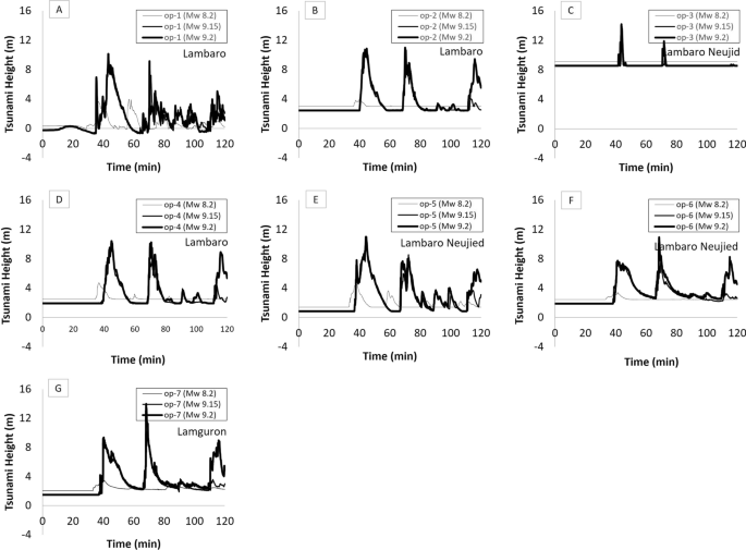
The height of tsunami fluctuations at observation points op-1 to op-7
In scenario 3, with a magnitude of 9.2 Mw, there is no significant difference compared to the scenario representing the earthquake scale during the previous tsunami, as proposed by Koshimura et al. (2009). However, the height and extent of inundation are slightly larger than those for the 9.15 Mw scale. A comparison of the maximum inundation achieved for the 9.15 Mw and 9.2 Mw scenarios is presented in Fig. 7.
The heights of the tsunamis on the land were observed at several locations (observation points, op) spread across 7 points within the study area (indicated by black dots in Fig. 6). Three observation stations in Fig. 6 correspond to the same reference points as the post-survey conducted by Lavigne et al. (2009). The post-survey results recorded inundation depths of 12.3 m, 20 m, and 13.7 m for op-1, op-2, and op-3, respectively. The modeling results for the 2004 IOT, represented by the orange lines in Fig. 7a–c, indicate differences in the elevation of inundation compared to field data. As previously discussed, scenario 2 (9.15 Mw) cannot fully represent the 2004 Tsunami reconstruction due to the changed topographic and land use conditions. Furthermore, bathymetry data, serving as secondary data, play a significant role in determining tsunami characteristics, especially in shallow waters, including the influence of seabed roughness. The delay in the arrival of tsunami waves to the coast, linked to both wave elevation and celerity, can be ascribed to the geographical location of the area and the influence of the local bathymetry, which has the capability to either amplify or diminish the magnitude of the waves as they propagate towards the shoreline. These conclusions align with previous scientific investigations that underscore the significance of the local bathymetry in shaping the characteristics of tsunamis (Murotani et al. 2015).
Figure 7d–g present the measurements of tsunami inundation in each village (gampong) within the study area for all modeling scenarios. These figures also reveal two primary waves arriving at the shore with a time difference of 20 min. Lambaro, located furthest to the west, experiences a tsunami of approximately 3 m for the small earthquake scenario and around 7–8 m for earthquakes more significant than 9 Mw. A tsunami with a depth of 4.3 m (8.2 Mw) and 9–10 m (> 9 Mw) inundates the western side of Lambaro Neujid. On the eastern side of the area, wave heights range from 3 m for the 8.2 Mw generation to 6.3–8 m for earthquakes more significant than 9 Mw, influenced by the presence of hills that obstruct waves from the west. In Lamguron, a tsunami inundation of 3.7 m occurs for scenario 1, while it ranges from 9 to 10 m for scenarios 2 and 3.
Knowledge and community preparedness
This study aims to assess the knowledge and perceptions of coastal communities to understand and evaluate their preparedness for tsunami disasters. The study area is a vulnerable region directly impacted by a tsunami two decades ago. The experiences of these coastal communities play a significant role in realizing their preparedness and resilience in mitigating future tsunami events. The distribution of respondents interviewed can be seen in the previously mentioned Fig. 2 (marked with orange dots). The parameters evaluated in this study include the basic knowledge of the community about tsunami phenomena and their impacts, emergency response plans as preparedness efforts for disasters, and the adaptation of early warning systems as a manifestation of mitigation efforts.
The assessment results based on the parameter of basic knowledge about tsunami phenomena are presented in Fig. 8. The local community has a good understanding that earthquakes generate tsunamis. However, only 42% are aware that underwater landslides can also trigger tsunamis. The rarity of tsunamis caused by landslides has resulted in a need for more information for the community. Based on records from 1666 to 1999, tsunamis in Indonesia were primarily triggered by earthquakes (90%), followed by volcanic eruptions accounting for 8%, and only 1% were caused by landslides (Latief et al. 2000). The recent tsunamis that struck the coastal areas of the Sunda Strait less than four years ago did not receive much attention from the local population. However, the experience of experiencing a disaster serves as valuable knowledge for the community. After an earthquake, most of the community understands that the receding of sea waters is a sign of an impending tsunami (88%). The 2004 Indian Ocean Tsunami experience has become the basis of knowledge for the community that the receding of sea waters always precedes a tsunami phenomenon. However, it should be noted that not all tsunami events (whether triggered by earthquakes or non-earthquake factors) are preceded by sea water receding, as was the case in the 2010 Mentawai Tsunami. Other tsunami arrival indicators, such as the roaring sound from the sea before the tsunami inundates the land, are also known by the community (85%) and changes in animal behavior (52%).
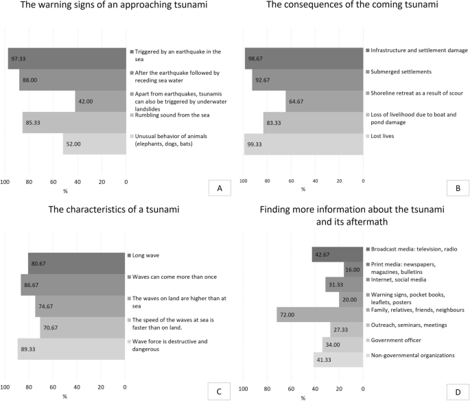
Assessment results regarding general knowledge of tsunami disasters
The community is well aware that the impacts of tsunamis result in loss of life, damage to settlements and other infrastructure, and loss of livelihoods. The severity of past tsunami events remains ingrained in the community’s memories, especially for respondents who were direct victims of the 2004 Indian Ocean Tsunami, experiencing the loss of family members or material possessions. 75.33% or 113 out of 150 respondents interviewed for this study were victims of the 2004 Indian Ocean Tsunami. However, knowledge of shoreline retreat due to tsunami-induced erosion is only understood by a portion of the community (64.67%). The recovery process of the Ulee Lheue Bay shoreline has been relatively successful after 19 years. However, there are still areas, such as abandoned fishponds, where the shoreline recovery has yet to be fully achieved. The younger generation of respondents needs to be fully aware of the changes in the shoreline that occurred after the tsunami. Monitoring shoreline recovery stages in the study area can be referred to in Syamsidik et al. (2015).
The community possesses a reasonably good understanding of tsunami characteristics, with an approximate 75–89% range. They agree that tsunamis are long waves, waves can arrive more than once, wave height is much greater when it reaches the shore compared to when it is in the sea, wave velocity is faster at sea than when it reaches the land, and the force carried by a tsunami is highly destructive and dangerous.
The community’s primary source of tsunami information is primarily obtained through interactions among family members, relatives, friends, and neighbors, accounting for 72%. This factor is influenced by the local culture of gathering and discussing in coffee shops and other public places. Information media such as television and radio also increase community knowledge (42.67%). Socialization efforts carried out by non-governmental organizations or community-based organizations also impact local community knowledge. Additionally, information is received by the community through government socialization, print media, and interactions with the internet and social media. In recent years, social media has experienced rapid development and is favored by the public as a means of information dissemination. Approximately 31% of the community accesses disaster-related information through social media, influenced by the generational differences among the respondents. Social media has the potential for widespread dissemination of disaster conditions, whether providing real-time information during a disaster or conveying lessons learned from past disasters (Simon et al. 2015). However, it should be noted that there is also the potential for misinformation. It was also observed in the field that meetings or seminars involving the community have a positive role in enhancing knowledge, such as knowledge dissemination forums conducted by several tsunami researchers in the field.
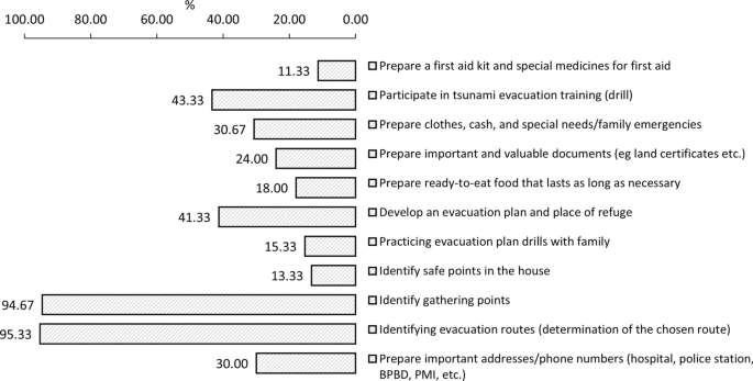
The form of emergency response plans as community preparedness efforts for future tsunami threats is shown in Fig. 9. Almost 95% of the populace has successfully established designated assembly areas and routes for evacuation in case of calamities. The study area incorporates evacuation indicators, depicted by white arrows in Fig. 2, which delineate the path to shelters. All the shelters are strategically positioned in the vicinity of the hill situated behind the villages. The local residents have a comprehensive understanding of the evacuation signage that has been well-established and acknowledged within the study area. The study area has well-recognized and understood evacuation signs for the local residents. Other preparedness efforts include around 43.33% and 41.33% of the community participating in training or evacuation drills (tsunami drills) and formulating evacuation plans and shelter locations. The community also prepares necessary supplies for emergencies, such as clothing, cash, important telephone numbers, and essential documents (24–30%). However, only a small portion of the community (less than 15%) implements household-level emergency protocols, such as preparing first aid kits or emergency medications, identifying safe spots within their homes, and practicing evacuation plans with their families. The low awareness of building a culture of preparedness at the household level is of particular concern. The short evacuation time during a disaster highlights that the success of mitigation efforts depends on the community’s swift response in self-evacuation. Therefore, self-rescue success depends on planning with various scenarios (such as the timing of the disaster, family members present at home during the event, and others) and practicing evacuation drills together with family members. There is an initiative to create Standard Operating Procedures (SOPs) at the household level related to emergency preparedness. These SOPs allocate specific tasks or roles to each family member during a disaster event, aiming to enhance preparedness and response.
The assessment results regarding the emergency response plan
The significance of this implementation can be observed in the case of the 2012 double earthquake event. On that day, earthquakes with magnitudes of 8.6 Mw and 8.2 Mw occurred, triggering evacuation orders for coastal areas. Nevertheless, timely siren activation was prevented by an electrical outage and the absence of an available power backup system (Syamsidik et al. 2021). Additionally, the lack of trained personnel to operate the siren towers further complicated the situation, resulting in delays in evacuation. Despite these challenges, it is noteworthy that a spontaneous evacuation process initiated by the people played a significant positive role. This spontaneous response represented a marked improvement compared to the 2004 Indian Ocean Tsunami, highlighting the importance of community-level preparedness and the need for further improvement in emergency protocols.
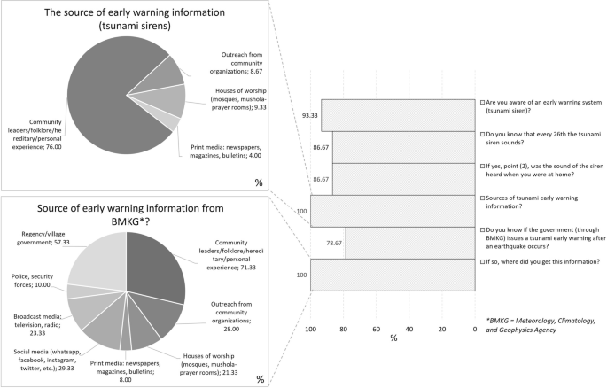
Figure 10 displays the local community’s knowledge of early warning systems. This parameter represents the community’s awareness of the existing early warning system. Following the 2004 tsunami, sirens were installed in the Aceh region as part of the tsunami early warning system and the alerts issued by the Meteorology, Climatology, and Geophysics Agency (BMKG) government agency. Most of the community is familiar with the tsunami sirens (93.33%) and knows they are sounded on the 26th of each month and can be heard in people’s homes (86.67%). These data indicate that while some individuals are unaware of the existence of tsunami sirens (16.67%), there are also those who are aware of the sirens but not of their monthly periodic sounding (6.66%). Knowledge about early warnings is predominantly obtained from community leaders and intercommunity stories (76%), compared to religious institutions (9.33%), community organizations’ outreach (8.67%), and print media (4%). The community is also aware of the tsunami alerts issued by the BMKG after an earthquake (78.67%). This information is primarily acquired by the community through influential figures and cross-community stories (71.33%), as well as through local government district/village outreach (57.33%) and community organizations’ outreach (28%).
The assessment results regarding the community’s response to early warnings
The relationship between community preparedness and tsunami potential
The inventory of knowledge and community response towards tsunamis indicates the level of community preparedness. The level of preparedness is excellent concerning knowledge about tsunamis. Most of the community had firsthand experience with the tsunami 19 years ago, while others were indirectly affected. The knowledge gained through these experiences has become a strong memory that can be implemented as an asset in facing future disasters. Additional knowledge regarding tsunami characteristics must be shared with the community to enhance their resilience. Knowledge has been disseminated among the community through socialization efforts, stakeholder involvement, and community leaders. However, encouraging direct participation in disaster preparedness activities would positively impact disaster mitigation (Witvorapong et al. 2015).
The concept of a systematic emergency response plan plays a crucial role in responding to actions that need to be taken during a limited timeframe when a disaster occurs. According to the tsunami simulation scenario corresponding to each village, the projected duration for the waves to arrive at the coastline amounts to a total of 20 min. In the event of a minor earthquake, the anticipated height of the waves may descend to roughly 3 m in the westernmost region, whereas a more substantial earthquake could result in a wave height of approximately 7–8 m. Consequently, given the limited timeframe available for self-preservation, it is imperative for the community to accurately ascertain the most suitable routes for evacuation as well as identify appropriate locations for vertical evacuation. The application of emergency response protocols at the household level needs to be higher. Implementing protocols within households is essential for self-evacuation. It begins with determining the response each family member needs to take when an earthquake occurs and extends to assigning tasks among family members during self-evacuation. Scenarios can be incorporated into household-scale emergency response plans, such as considering the presence of family members outside the house when a disaster strikes, determining meeting points, and other relevant factors.
Early warning parameters indicate the level of community preparedness in making evacuation decisions. The existence of tsunami sirens serves as a device that emphasizes the limited time available for evacuation during damage or human error (Oktari et al. 2014). Local wisdom within the community is critical to saving lives during tsunamis. The Simeulue community exemplified this during the 2004 event, where the continuous narration of Smong across generations has built disaster awareness and serves as a form of early warning knowledge (Rahman et al. 2018).
It is important for local authorities to inform residents about the tsunami arrival time and how to recognize the potential ground shaking that could lead to a tsunami. The emphasis placed by local authorities on evacuation preparation time can be reduced by preparing grab-and-go kits well before an earthquake strikes (Chen et al. 2022).
The study area in the Peukan Bada District remains highly vulnerable to tsunamis along the Ulee Lheue Bay coast. Previous simulation results showed that the inundation distance in the Lampageu area extends up to 1 km inland. For small-scale earthquakes compared to the 2004 event, the tsunami height in this area ranges from 3 to 4 m, with the run-up reaching 500 m towards residential areas. Therefore, in addition to strengthening community preparedness, implementing an integrated mitigation system that considers the environment in the area is crucial. A mitigation system provides additional time for the community to conduct self-evacuation.
A connection between the community and the theoretical and practical implications based on the findings could be suggested for each stakeholder. For the community, the research holds the potential to inform and guide various actions, including raising awareness about tsunami risks, organizing regular evacuation drills, and promoting community-driven disaster preparedness efforts. In the governmental and regulatory context, the implications encompass recommendations for measures such as implementing regulations to manage coastal development, formulating comprehensive coastal zone management plans, and strategically constructing tsunami shelters in vulnerable areas.
Furthermore, the development of mitigation concepts in the Ulee Lheue Bay coastal area should consider the social aspects of the community and the environmental conditions. The mitigation concept should also be integrated with the existing mitigation system, such as evacuation routes. The damaged aquaculture ponds along the coastline resulting from previous tsunamis can be utilized as buffer zones. These buffer zones can be established by planting coastal vegetation along the shoreline, with Casuarina equisetifolia (coastal casuarina) being a recommended vegetation species compared to mangroves due to the limited success of mangrove species in this location (Syamsidik et al., 2015). Similar coastal characteristics found in locations such as Lembah Geuruete (Benazir et al., 2017) and Pacitan Bay (Muhari et al. 2012) are also present in the study area. However, to allow coastal vegetation to grow and provide protection against wave impacts, the damaged aquaculture ponds from 2004 need to be reclaimed. These practical suggestions facilitate the translation of theoretical insights into real-world applications, ultimately strengthening tsunami preparedness and mitigation efforts within the community and enhancing overall resilience.
Nevertheless, this study has limitations associated with its close association with local geographic conditions, requiring adjustments in geographical settings when applied to other areas. Additionally, from a modeling perspective, limitations exist regarding bathymetric data, which are mainly secondary, and the number of scenarios conducted, as only the two most recent tsunamis (2012 and 2004) and one worst-case scenario with potential were modeled. Furthermore, the modeled tsunami sources were based solely on tectonic earthquake mechanisms, while the waters north of Sumatra also have the potential for tsunamis generated by submarine landslides (Haridhi et al. 2022).
Conclusion
This investigation examining the simulation of a tsunami has yielded valuable insights into the potential impact of earthquakes of varying magnitudes on the formation of tsunamis and the resulting flooding of coastal areas. The modeling approach employed in this study took into consideration critical factors such as fault displacement, rupture length, and the topographical characteristics of the region under investigation. Importantly, the findings of this study demonstrate that even a relatively modest earthquake with a magnitude of 8.2 Mw can lead to significant flooding in the affected villages, highlighting the crucial role played by local topography in determining the extent of inundation. As earthquake magnitudes exceed 9 Mw, the impact of the resulting tsunami escalates significantly, resulting in higher wave heights and more extensive areas being flooded. This research also highlights notable differences in the scale and depth of flooding depending on the magnitude of the earthquake and the unique topographic features of each village. Notably, the scenario with an earthquake magnitude of 8.2 Mw resulted in flooding across all villages in the study area, with Lamteungoh experiencing the most extensive inundation due to its proximity to the sea and relatively gentle topography. These findings underscore the need to consider dynamic changes in topography and land use over time when conducting assessments of tsunami risk. Furthermore, the study emphasizes the complexity of tsunami modeling and the requirement for comprehensive data, particularly in relation to the influence of local bathymetry on tsunami characteristics and the observable delay in the arrival of waves. This study has made a significant contribution to our understanding of the hazards posed by tsunamis and has emphasized the importance of effective disaster preparedness and measures to mitigate the impact of tsunamis in regions that are vulnerable to such events.
Moreover, this study provides insight into the critical factors that influence the preparedness of communities and the potential for reducing the impact of tsunamis. The findings illustrate the significant roles played by community knowledge and direct experiences of tsunamis in shaping the preparedness levels of communities. Ongoing efforts to disseminate knowledge through socialization programs and the active involvement of stakeholders have contributed to the development of increased community awareness. However, the study highlights the need to further enhance preparedness by actively encouraging direct participation in disaster preparedness activities.
Furthermore, this study highlights the importance of establishing a systematic emergency response plan at the household level to enable effective and timely actions during a tsunami event. Clearly defining roles and responsibilities for each family member and incorporating various scenarios into the emergency response plan are considered essential steps to improve preparedness.
In addition, early warning systems, including tsunami sirens, are identified as crucial tools for alerting communities and providing limited time for evacuation. The integration of local wisdom, which includes traditional knowledge passed down through generations, along with modern early warning systems, has been shown to enhance community preparedness and response capabilities.
Nevertheless, it is important to acknowledge the limitations of this study. The findings are inherently associated with the specific geographical conditions of the study area, and adjustments would be necessary when extrapolating them to different regions. Furthermore, enhancing the comprehensiveness of bathymetric data and expanding the range of modeling scenarios, such as incorporating submarine landslides, would undoubtedly strengthen the findings of this study.
In conclusion, this study serves as a valuable asset for advancing the preparedness of communities and mitigating the adverse effects of tsunamis. It highlights the importance of disseminating knowledge, actively involving communities, implementing early warning systems, and combining traditional wisdom with modern approaches. By implementing comprehensive mitigation systems and utilizing appropriate coastal vegetation, vulnerable coastal regions can strengthen their ability to withstand the imminent threat of tsunamis. Future research efforts should prioritize adapting these findings to various geographical contexts and expanding the range of modeling scenarios to further enhance preparedness and mitigation endeavors.
References
Ammon CJ, Ji C, Thio HK, Robinson D, Ni S, Hjorleifsdottir V, Kanamori H, Lay T, Das S, Helmberger D, Ichinose G, Polet J, Wald D (2005) Rupture process of the 2004 Sumatra-Andaman earthquake. Science 308(5725):1133–1139. https://doi.org/10.1126/science.1112260
Badan Pusat Statistik (2020) Kecamatan Peukan Bada dalam Angka 2020. BPS Kabupaten Aceh Besar
Triatmadja R, Rahardjo AP, Yuwono N (2017) Comparison of methods for simulating Tsunami Run-up through Coastal forests. Sci Tsunami Hazards 36(3):167–182
Chen C, Wang H, Lindell MK, Jung MC, Siam MRK (2022) Tsunami preparedness and resilience: evacuation logistics and time estimations. Trans Res D Trans Environ 109:103324
Chlieh M, Avouac JP, Hjorleifsdottir V, Song TRA, Ji C, Sieh K, Sladen A, Hebert H, Prawirodirdjo L, Bock Y, Galetzka J (2007) Coseismic slip and afterslip of the great Mw 9.15 Sumatra-Andaman earthquake of 2004. Bull Seismol Soc Am. https://doi.org/10.1785/0120050631
Dahdouh-Guebas F, Jayatissa LP, di Nitto D, Bosire JO, Seen D, lo, Koedam N, (2005) How effective were mangroves as a defence against the recent tsunami? Curr Biol. https://doi.org/10.1016/j.cub.2005.06.008
Daly P, Sieh K, Seng TY, McKinnon EE, Parnell AC, Ardiansyah, Feener RM, Ismail N, Nizamuddin, Majewski J (2019) Archaeological evidence that a late 14th-century tsunami devastated the coast of northern Sumatra and redirected history. Proc Natl Acad Sci USA 116(24):11679–11686. https://doi.org/10.1073/pnas.1902241116
Danielsen F, Sørensen MK, Olwig MF, Selvam V, Parish F, Burgess ND, Hiraishi T, Karunagaran VM, Rasmussen MS, Hansen LB, Quarto A, Suryadiputra N (2005) The Asian tsunami: a protective role for coastal vegetation. Science 310(5748):643. https://doi.org/10.1126/science.1118387
Delescluse M, Chamot-Rooke N, Cattin R, Fleitout L, Trubienko O, Vigny C (2012) April 2012 intra-oceanic seismicity off Sumatra boosted by the Banda-Aceh megathrust. Nature 490(7419):240–244. https://doi.org/10.1038/nature11520
Duputel Z, Kanamori H, Tsai VC, Rivera L, Meng L, Ampuero JP, Stock JM (2012) The 2012 Sumatra great earthquake sequence. Earth Planet Sci Lett 351–352:247–257. https://doi.org/10.1016/j.epsl.2012.07.017
Fahmi M, Syamsidik Fatimah E, Al’Ala M, (2017) A decade process of coastal land use changes in Peukan Bada-Aceh after the 2004 Indian Ocean Tsunami. IOP Confer Ser Earth Environ Sci. https://doi.org/10.1088/1755-1315/56/1/012012
Gahalaut VK, Catherine JK (2006) Rupture characteristics of 28 March 2005 Sumatra earthquake from GPS measurements and its implication for tsunami generation. Earth Planet Sci Lett 249(1–2):39–46. https://doi.org/10.1016/j.epsl.2006.07.015
Griffin C, Ellis D, Beavis S, Zoleta-Nantes D (2013) Coastal resources, livelihoods and the 2004 Indian Ocean tsunami in Aceh, Indonesia. Ocean Coast Manag 71:176–186. https://doi.org/10.1016/j.ocecoaman.2012.10.017
Hanks TC, Kanamori H (1979) A moment magnitude scale. J Geophys Res B: Solid Earth 84(B5):2348–2350. https://doi.org/10.1029/JB084iB05p02348
Haridhi HA, Huang BS, Wen KL, Denzema D, Prasetyo A, Lee CS (2018) A study of large earthquake sequences in the Sumatra subduction zone and its possible implications. Terr Atmos Ocean Sci 29(6):635–652. https://doi.org/10.3319/TAO.2018.08.22.01
Haridhi HA, Shouh-Huang B, Liang-Wen K, Mirza A, Rizal S, Purnawan S, Fajri I, Klingelhoefer F, Shine-Liu C, Lee S, Wilson C, Wu CR, Setiawan T-RI, Phung VB (2022) Tsunami scenario triggered by submarine landslide offshore of northern Sumatra Island and its hazard assessment. Natl Hazards Earth Syst Sci. https://doi.org/10.5194/nhess-2021-375
Horspool N, Pranantyo I, Griffin J, Latief H, Natawidjaja DH, Kongko W, Cipta A, Bustaman B, Anugrah SD, Thio HK (2014) A probabilistic tsunami hazard assessment for Indonesia. Nat Hazards Earth Syst Sci 14(11):3105–3122. https://doi.org/10.5194/nhess-14-3105-2014
Hsu YJ, Simons M, Avouac JP, Galeteka J, Sieh K, Chlieh M, Natawidjaja D, Prawirodirdjo L, Bock Y (2006) Frictional afterslip following the 2005 Nias-Simeulue earthquake. Sumatra Sci 312(5782):1921–1926. https://doi.org/10.1126/science.1126960
Imamura F, Boret SP, Suppasri A, Muhari A (2019) Recent occurrences of serious tsunami damage and the future challenges of tsunami disaster risk reduction. Prog Disaster Sci. https://doi.org/10.1016/j.pdisas.2019.100009
Ismail N, Okazaki K, Ochiai C, Fernandez G (2018) Livelihood changes in Banda Aceh, Indonesia after the 2004 Indian Ocean Tsunami. Int J Disaster Risk Reduct 28:439–449. https://doi.org/10.1016/j.ijdrr.2017.09.003
Kim DC, Kim KO, Choi BH, Kim KH, Pelinovsky E (2013) Three-dimensional runup simulation of the 2004 Indian Ocean tsunami at the Lhok Nga twin peaks. J Coastal Res 65:272–277. https://doi.org/10.2112/si65-047.1
Koshimura S, Oie T, Yanagisawa H, Imamura F (2009) Developing fragility functions for tsunami damage estimation using numerical model and post-tsunami data from banda aceh, Indonesia. Coastal Eng J 51(3):243–273. https://doi.org/10.1142/S0578563409002004
Lambotte S, Rivera L, Hinderer J (2006) Rupture length and duration of the 2004 Aceh-Sumatra earthquake from the phases of the Earth’s gravest free oscillations. Geophys Res Letthttps://doi.org/10.1029/2005GL024090
Lange D, Tilmann F, Henstock T, Rietbrock A, Natawidjaja D, Kopp H (2018) Structure of the central Sumatran subduction zone revealed by local earthquake travel-time tomography using an amphibious network. Solid Earth 9(4):1035–1049. https://doi.org/10.5194/se-9-1035-2018
Latief H, Puspito NT, Imamura F (2000) Tsunami catalog and zones in Indonesia. J Nat Disaster Sci 22(1):25–43
Lavigne F, Paris R, Grancher D, Wassmer P, Brunstein D, Vautier F, Leone F, Flohic F, de Coster B, Gunawan T, Gomez C, Setiawan A, Cahyadi R, Fachrizal (2009) Reconstruction of tsunami inland propagation on December 26, 2004 in Banda Aceh, Indonesia, through field investigations. Pure Appl Geophys 166(1–2):259–281. https://doi.org/10.1007/s00024-008-0431-8
Lay T, Kanamori H, Ammon CJ, Nettles M, Ward SN, Aster RC, Beck SL, Bilek SL, Brudzinski MR, Butler R, Deshon HR, Ekström G, Satake K, Sipkin S (2005) The great Sumatra-Andaman earthquake of 26 December 2004. Science 308(5725):1127–1133. https://doi.org/10.1126/science.1112250
Li L, Switzer AD, Wang Y, Weiss R, Qiu Q, Chan CH, Tapponnier P (2015) What caused the mysterious eighteenth century tsunami that struck the southwest Taiwan coast? Geophys Res Lett 42(20):8498–8506. https://doi.org/10.1002/2015GL065567
Liu PLF, Cho YS, Yoon SB, Seo SN (1995) Numerical simulations of the 1960 Chilean Tsunami propagation and inundation at Hilo, Hawaii. In Tsuchiya Y, Shuto N (eds) Tsunami: progress in prediction, disaster prevention and warning. Springer, Netherlands, pp 99–115. https://doi.org/10.1007/978-94-015-8565-1_7
Liu PLF, Woo S-B, Cho Y-S (1998) Computer program for tsunami propagation and inundation
Mansinha L, Smylie DE (1971) The displacement fields of inclined faults. Bull Selsmol Sodety Am 61(5):1433–1440
Martin SS, Li L, Okal EA, Morin J, Tetteroo AEG, Switzer AD, Sieh KE (2019) Reassessment of the 1907 Sumatra tsunami earthquake based on macroseismic, seismological, and tsunami observations, and modeling. Pure Appl Geophys 176(7):2831–2868. https://doi.org/10.1007/s00024-019-02134-2
McCaffrey R (2009) The tectonic framework of the Sumatran subduction zone. In Ann Rev Earth Planet Sci 37:345–366. https://doi.org/10.1146/annurev.earth.031208.100212
Monecke K, Finger W, Klarer D, Kongko W, McAdoo BG, Moore AL, Sudrajat SU (2008) A 1,000-year sediment record of tsunami recurrence in northern Sumatra. Nature 455(7217):1232–1234. https://doi.org/10.1038/nature07374
Muhari A, Mück M, Diposaptono S, Spahn H (2012) Tsunami Mitigation Planning in Pacitan, Indonesia: a review of existing efforts and Ways ahead. Sci Tsunami Hazards 31(4):244
Mulia IE, Ishibe T, Satake K, Gusman AR, Murotani S (2020) Regional probabilistic tsunami hazard assessment associated with active faults along the eastern margin of the Sea of Japan. Earth Planets Space. https://doi.org/10.1186/s40623-020-01256-5
Murotani S, Iwai M, Satake K, Shevchenko G, Loskutov A (2015) Tsunami forerunner of the 2011 Tohoku earthquake observed in the sea of Japan. Pure Appl Geophys 172(3–4):683–697. https://doi.org/10.1007/s00024-014-1006-5
Newman Av, Hayes G, Wei Y, Convers J (2011) The 25 October 2010 Mentawai tsunami earthquake, from real-time discriminants, finite-fault rupture, and tsunami excitation. Geophys Res Lett. https://doi.org/10.1029/2010GL046498
Okada Y (1985) Surface deformation due to Shear and Tensile Faults in a half-space. Bull Seismol Soc Am 75(4):1135–1154
Oktari RS, Munadi K, Ridha M (2014) Effectiveness of dissemination and communication element of Tsunami early warning system in Aceh. Proc Econ Finance 18:136–142. https://doi.org/10.1016/s2212-5671(14)00923-x
Oktari RS, Syamsidik, Idroes R, Sofyan H, Munadi K (2020) City resilience towards coastal hazards: An integrated bottom-up and top-down assessment. Water. https://doi.org/10.3390/w12102823
Park J, Song TRA, Tromp J, Okal E, Stein S, Roult G, Clevede E, Laske G, Kanamori H, Davis P, Berger J, Braitenberg C, van Camp M, Lei X, Sun H, Xu H, Rosat S (2005) Earth’s free oscillations excited by the 26 December 2004 Sumatra-Andaman earthquake. Science 308(5725):1139–1144. https://doi.org/10.1126/science.1112305
Philibosian B, Sieh K, Avouac JP, Natawidjaja DH, Chiang HW, Wu CC, Shen CC, Daryono MR, Perfettini H, Suwargadi BW, Lu Y, Wang X (2017) Earthquake supercycles on the Mentawai segment of the Sunda megathrust in the seventeenth century and earlier. J Geophys Res Solid Earth 122(1):642–676. https://doi.org/10.1002/2016JB013560
Pusgen (2017) Peta Sumber dan Bahaya Gempa Indonesia Tahun 2017. Pusat Studi Gempa Nasional (Indonesia)
Rahman A, Sakurai A, Munadi K (2018) The analysis of the development of the Smong story on the 1907 and 2004 Indian Ocean tsunamis in strengthening the Simeulue island community’s resilience. Int J Disaster Risk Reduct 29:13–23. https://doi.org/10.1016/j.ijdrr.2017.07.015
Rubin CM, Horton BP, Sieh K, Pilarczyk JE, Daly P, Ismail N, Parnell AC (2017) Highly variable recurrence of tsunamis in the 7400 years before the 2004 Indian Ocean tsunami. Nat Commun. https://doi.org/10.1038/ncomms16019
Satake K (2014) Advances in earthquake and tsunami sciences and disaster risk reduction since the 2004 Indian ocean tsunami. Geosci Lett. https://doi.org/10.1186/s40562-014-0015-7
Selva J, Lorito S, Volpe M, Romano F, Tonini R, Perfetti P, Bernardi F, Taroni M, Scala A, Babeyko A, Løvholt F, Gibbons SJ, Macías J, Castro MJ, González-Vida JM, Sánchez-Linares C, Bayraktar HB, Basili R, Maesano FE (2021) Probabilistic tsunami forecasting for early warning. Nat Commun. https://doi.org/10.1038/s41467-021-25815-w
Sepúlveda I, Haase JS, Carvajal M, Xu X, Liu PLF (2020) Modeling the sources of the 2018 Palu, Indonesia, Tsunami using videos from social media. J Geophys Res Solid Earth. https://doi.org/10.1029/2019JB018675
Sieh K, Natawidjaja D (2000) Neotectonics of the Sumatran fault, Indonesia. J Geophys Res Solid Earth 105(B12):28295–28326. https://doi.org/10.1029/2000jb900120
Sieh K, Daly P, Edwards McKinnon E, Pilarczyk JE, Chiang HW, Horton B, Rubin CM, Shen CC, Ismail N, Vane CH, Feener RM (2015) Penultimate predecessors of the 2004 Indian Ocean tsunami in Aceh, Sumatra: stratigraphic, archeological, and historical evidence. J Geophys Res Solid Earth 120(1):308–325. https://doi.org/10.1002/2014JB011538
Simon T, Goldberg A, Adini B (2015) Socializing in emergencies: a review of the use of social media in emergency situations. Int J Inf Manage 35(5):609–619. https://doi.org/10.1016/j.ijinfomgt.2015.07.001
Subarya C, Chlieh M, Prawirodirdjo L, Avouac JP, Bock Y, Sieh K, Meltzner AJ, Natawidjaja DH, McCaffrey R (2006) Plate-boundary deformation associated with the great Sumatra-Andaman earthquake. Nature 440:46–51. https://doi.org/10.1038/nature04522
Syamsidik T, Suppasri A, Al’Ala M, Luthfi M, Comfort LK (2019) Assessing the tsunami mitigation effectiveness of the planned Banda Aceh outer Ring Road (BORR), Indonesia. Nat Hazards Earth Syst Sci 19(1):299–312. https://doi.org/10.5194/nhess-19-299-2019
Syamsidik, Iskandar A, Rasyif TM (2015) Progress of coastal line rehabilitation after the Indian ocean tsunami around Banda Aceh coasts. In Shaw R (ed) Recovery from the Indian ocean tsunami: a ten-year journey. Springer, Japan, pp 175–189. https://doi.org/10.1007/978-4-431-55117-1_13
Syamsidik AN, Oktari RS, Fahmi M (2019) Aceh Pasca 15 Tahun Tsunami: Kilas Balik dan Proses Pemulihan. Tsunami and Disaster Research Center (TDMRC) Universitas Syiah Kuala
Syamsidik Oktari RS, Nugroho A, Fahmi M, Suppasri A, Munadi K, Amra R (2021) Fifteen years of the 2004 Indian Ocean Tsunami in Aceh-Indonesia: mitigation, preparedness and challenges for a long-term disaster recovery process. Int J Disaster Risk Reduct. https://doi.org/10.1016/j.ijdrr.2021.102052
Synolakis CE, Bernard EN (2006) Tsunami science before and beyond Boxing Day 2004. Philos Trans R Soc A Math Phys Eng Sci 364(1845):2231–2265. https://doi.org/10.1098/rsta.2006.1824
Tabei T, Kimata F, Ito T, Gunawan E, Tsutsumi H, Ohta Y, Yamashina T, Soeda Y, Ismail N, Nurdin I, Sugiyanto D, Meilano I (2017) Geodetic and geomorphic evaluations of earthquake generation potential of the northern Sumatran fault, Indonesia. Int Assoc Geodesy Symposia 145:21–28. https://doi.org/10.1007/1345_2015_200
Tsuji Y (2006) Damage and height distribution of Sumatra Earthquake-Tsunami damage and height distribution of Sumatra Earthquake-Tsunami of in Banda Aceh City and its environs. J Disaster Res 1(1):103–115
Tursina S, Kato S, Afifuddin M (2021) Coupling sea-level rise with tsunamis: projected adverse impact of future tsunamis on Banda Aceh city Indonesia. Int J Disaster Risk Reduct. https://doi.org/10.1016/j.ijdrr.2021.102084
United Nations Office for Disaster Risk Reduction (2015) Sendai framework for disaster risk reduction 2015–2030
Vallée M (2007) Rupture properties of the giant Sumatra earthquake imaged by empirical green’s function analysis. Bull Seismol Soc Am. https://doi.org/10.1785/0120050616
Wang X (2009) User manual for COMCOT Version 1.7 (first draft)
Wang X, Liu PLF (2006) An analysis of 2004 Sumatra earthquake fault plane mechanisms and Indian Ocean tsunami. J Hydraul Res 44(2):147–154. https://doi.org/10.1080/00221686.2006.9521671
Wang D, Mori J, Uchide T (2012) Supershear rupture on multiple faults for the mw 8.6 off Northern Sumatra, Indonesia earthquake of April 11, 2012. Geophys Res Lett. https://doi.org/10.1029/2012GL053622
Wassmer P, Gomez C, Iskandasyah TYWM, Lavigne F, Sartohadi J (2015) Contribution of anisotropy of magnetic susceptibility (AMS) to reconstruct flooding characteristics of a 4220 BP tsunami from a thick unconsolidated structureless deposit (Banda Aceh, Sumatra). Front Earth Sci. https://doi.org/10.3389/feart.2015.00040
Weller O, Lange D, Tilmann F, Natawidjaja D, Rietbrock A, Collings R, Gregory L (2012) The structure of the Sumatran Fault revealed by local seismicity. Geophys Res Lett. https://doi.org/10.1029/2011GL050440
Wells DL, Coppersmith KJ (1994) New empirical Relationships among Magnitude, rupture length, rupture width, rupture area, and Surface Displacement. Bull Seismol Soc Am 84(4):974–1002
Witvorapong N, Muttarak R, Pothisiri W (2015) Social participation and disaster risk reduction behaviors in tsunami prone areas. PLoS ONE. https://doi.org/10.1371/journal.pone.0130862
Yue H, Lay T, Koper KD (2012) En échelon and orthogonal fault ruptures of the 11 April 2012 great intraplate earthquakes. Nature 490(7419):245–249. https://doi.org/10.1038/nature11492
Acknowledgements
The authors would like to express gratitude to The Ministry of Education, Culture, Research, and Technology (Kemendikbudristek) Republic of Indonesia, Directorate General of Higher Education, Research, and Technology and the Directorate of Research and Community Engagement of Syiah Kuala University for their financial support through the National Competitive Research Grant under the Basic Research scheme (SBK Riset Dasar), based on the Decree Number 25/UN11.2.1/PT.01.03/DPRM/2021 and Agreement/Contract Number 154/SP2H/LT/DPRM/2021, with the title “Mitigasi Tsunami Berbasis Soft-Structure dengan Tinjauan Aspek Lingkungan dan Sosial.“ This publication is a part of the research output funded by this grant. The authors would also like to extend sincere appreciation to all individuals and organizations who have contributed, directly or indirectly, to the successful completion of this research.
Author information
Authors and Affiliations
Contributions
B: conceptualization, simulation, data analysis, visualization, writing – original draft, and editing the manuscript. S: reviewing, revising, and improving the quality of the manuscript. YI: reviewing and revising the manuscript. NP: field survey for topography data.
Corresponding author
Ethics declarations
Competing interests
The authors declare no competing interests.
Additional information
Publisher’s Note
Springer Nature remains neutral with regard to jurisdictional claims in published maps and institutional affiliations.
Rights and permissions
Open Access This article is licensed under a Creative Commons Attribution 4.0 International License, which permits use, sharing, adaptation, distribution and reproduction in any medium or format, as long as you give appropriate credit to the original author(s) and the source, provide a link to the Creative Commons licence, and indicate if changes were made. The images or other third party material in this article are included in the article's Creative Commons licence, unless indicated otherwise in a credit line to the material. If material is not included in the article's Creative Commons licence and your intended use is not permitted by statutory regulation or exceeds the permitted use, you will need to obtain permission directly from the copyright holder. To view a copy of this licence, visit http://creativecommons.org/licenses/by/4.0/.
About this article

Cite this article
Benazir, Syamsidik, Idris, Y. et al. Connecting community’s perspectives on tsunami risk to anticipated future tsunamis: a reflection from a progress of tsunami preparedness from a coastal community in Aceh-Indonesia after 19 years of the 2004 Indian Ocean Tsunami. Geoenviron Disasters 10, 21 (2023). https://doi.org/10.1186/s40677-023-00252-7
Received:
Accepted:
Published:
DOI: https://doi.org/10.1186/s40677-023-00252-7